The town of Třebíč lies in a deep picturesque valley of the river Jihlava. Hotel Joseph1699 is located practically on its hillside and from the hotel you can go for easy and relaxing walks with beautiful views of the entire city center. The landscape of the Vysočina region around offers many possibilities for tourist trips around Třebíč. You can intersperse them with exploring the Třebíč monuments and around Třebíč (more info HERE and HERE) and attractions that are unique, including UNESCO monuments (more HERE). You can go “In the footsteps of abbots and rabbis” – the map is available in Information Centrum in the rear synagogue – distance 100 m from the hotel. The hotel is part of this route as Chudobinec – english Poorhouse (the hotel buildings were once used for this purpose within the self-government of the Jewish town).
You can plan bike trips as well. HERE
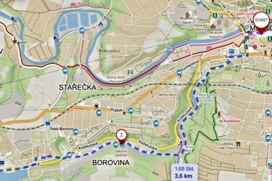
Tourist route 1: Through the Libušina valley to Borovina – approx. 7 km one direction
Take a walk through one of the most beautiful parks, which, thanks to the flat terrain, will please all undemanding tourists and especially families with children. Take a walk through the picturesque Libušina valley to the former Baťa plant, where you will find the Alternator Ecotechnical Center and try Wakeboard at pond called Borovinský rybník.
From Karlovo náměstí (square), go southwest to “Na Potoce” Street, which leads to valley called “Libušino údolí”, where the cycle path No. 26 Jihlava – Třebíč – Raabs leads. Following the cycle path, you will walk under the railway bridge, over the dam of Mácha’s Lake and you will reach a place with benches, where there is the possibility of rest and relaxation. Follow the park path through the valley to the crossroads at Janov’s mill. Here you turn right, leave the cycle path and on the way you walk to Alternator, which is the first building of the former BOPO factory complex (formerly Baťa’s plant). You can walk through the area to the roundabout and then to the pub Pod Hrází, where there is the possibility of refreshments. On the Borovinský rybník (pond) you can try the water attraction Wakeboard in Wakepark. You can go back to the center of public bus transport Třebíč, or return the way you came.
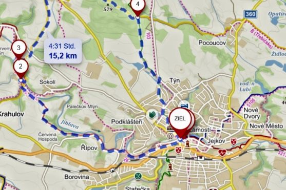
Tourist route 2: Račerovice circuit – 15 km
From the city center, go west walking upstream of the Jihlava River around the Polanka swimming pool. Follow the red tourist route through village Řípov and continue along the red to the valley of the river Jihlava to Padrtův mlýn (mill) near Sokolí village. Here you can relax and refresh yourself in a pleasant environment. After Padrtový mlýn, you will cross the river and continue along the yellow route, which turns right at the Pod Besídkou crossroads and takes you to village of Račerovice. You gradually ascend to the plateau, from where there are nice views of the Třebíč basin bordered by the distinctive hills “Zadní hora” and “Pekelný kopec”. Via village of Račerovice, follow the yellow sign to the Velká Dubinka forest. At the Dubina crossroads, turn onto the green route and return around the Zámiš pond to Třebíč.
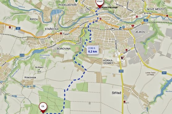
Tourist route 3: Trip to the “Hell’s Hill” with a lookout tower – 12 km there and back
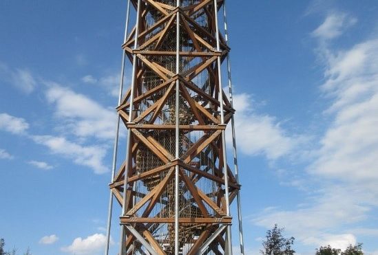
Hill Pekelny kopec is located in the southwest of Trebic, about 6 km from the center. The lookout tower has stood here in the past. It disappeared in the 1950s. A new nice lookout tower made of larch wood and steel was built on its top in 2014.
It follows the Jewish monuments in Třebíč. Its floor plan is a combination of two squares – reminiscent of the Star of David. It is 26.5 meters high, 108 wooden spiral stairs lead to the observation platform at a height of 23.3 meters, which is connected to the top of 16 spiral metal stairs. From the lookout tower there is a circular view of a large relatively flat area. In the north you can of course see Třebíč and the more distant small towns Budišov and Rudíkov, in the west villages Přibyslavice, Heraltice, and the lookout tower Mařenka, in the south town of Moravské Budějovice and closer Čáslavice and Sádek chateau. On the horizon you can see the hills of Drahanská Highlands with Zadní hora and Pavlovské vrchy with Děvín. The Schneeberg hill in the Austrian Alps, 160 km away, can also be seen with good visibility.
Only a short distance from the lookout tower has to go back the same way. Route then continues straight on, turns right and when you come across a green tourist sign, you can turn left and continue along it almost to the city. At the Terůvka crossroads, you can continue in a straight line along an unmarked road and return to the car park. The whole route is about 11.5 km long. If you continue on the green, there will be a central bus station to the town – it is about 3 km away.


